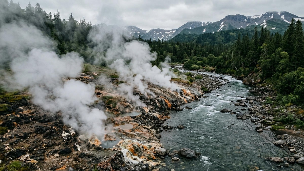
In a groundbreaking development for global environmental monitoring, specialists from the Institute of Volcanology and Seismology of the Far Eastern Branch of the Russian Academy of Sciences have for the first time measured the volume of carbon dioxide released into the atmosphere from the Nizhne-Shchapinsky thermal springs in Russia’s Kamchatka Peninsula. This pioneering effort has revealed that approximately seven tons of CO2 are emitted daily across an area of roughly two hectares along the banks of the Left Shchapina River, according to a report by Kommersant. This crucial baseline data is set to become a cornerstone for the regular monitoring of the nearby Kizimen volcano, at whose base this active hydrothermal system is situated.
Continuous CO2 seepage through the soil is a natural and pervasive process in regions characterized by high volcanic activity. These diffuse gas flows operate year-round, playing a significant role in the planet’s global carbon cycle and directly influencing climate patterns. Despite the phenomenon’s widespread nature, precise emission volumes in Kamchatka have previously only been documented for a handful of locations, such as Death Valley, the Uzon caldera, and the Bolshoy Semyachik massif. The inclusion of the Nizhne-Shchapinsky springs now significantly expands this vital dataset.
The recorded seven tons represent an initial benchmark. Elena Kalacheva, Deputy Director for Scientific Work at the Institute of Volcanology and Seismology FEB RAS, emphasizes that while this figure alone does not indicate whether it constitutes a normal or anomalous level, it establishes the essential starting point for comprehensive monitoring. “This is precisely where monitoring begins,” she explained. “Now we know what to base our observations on, allowing us to register any subsequent changes.” The carbon dioxide emanating from this area is of magmatic origin, meaning it comes directly from molten rock. A sharp increase in its surface presence could thus serve as an early warning sign for an impending eruption of Kizimen volcano, as magma degassing intensifies notably before volcanic events.
In tandem with these critical gas measurements, researchers also assessed the profound transformations of the local landscape. By comparing contemporary satellite imagery with records from a 1908 expedition by the Russian Geographical Society, they uncovered how the Left Shchapina River has entirely reshaped the valley over the past century. What is now an island rising from the riverbed was once an integral part of a unified thermal area on the right bank. Over time, the river’s waters eroded the soil, breached into a coastal lake, and subsequently isolated this landmass, which has since grown in size due to accumulating river sediment.
Such dynamic transformations underscore that hydrothermal systems do far more than merely alter the chemical composition of water bodies; they actively and physically reconfigure the terrain. Thermal waters erode riverbanks and create novel geological features from their own deposits. Research coordinated by the Vitus Bering Kamchatka State University is elevating these often-overlooked locales to objects of continuous scientific observation. Fluctuations in subterranean water activity and variations in gas flows remain critical markers of the complex processes hidden deep within one of the planet’s most seismically volatile regions, offering valuable insights into Earth’s internal dynamics and their global ramifications.